FORUM ARCHIVE — READ ONLY
Read-Only Archive — 68,067 posts · 4,889 threads · 2,978 members · preserved from 2006–2015
Official ongoing weather thread
Jul 31, 2011 04:17 AM #441
Dry as a bone over here...
Jul 31, 2011 04:31 AM #442
He may have meant it figuratively, Daniel.
(j/k we got a load for about 15 minutes too.)
(is anyone else giggling about "dump" "bone" and "load" or is it just me?)
(j/k we got a load for about 15 minutes too.)
(is anyone else giggling about "dump" "bone" and "load" or is it just me?)
Jul 31, 2011 04:37 AM #443
alanzona wrote:He may have meant it figuratively, Daniel.
(j/k we got a load for about 15 minutes too.)
(is anyone else giggling about "dump" "bone" and "load" or is it just me?)
I am now lol
Aug 04, 2011 11:27 AM #444
Same here :( radar showed a good sized cell over the house, went out side for about 30 min just a few drops, mostly wind some lightning but at 7pm there was still too much light to try & snap any pictures, so I just did my typical enh, it'll be over soon.
Aug 04, 2011 11:40 PM #445
Got off work about 10:30 and it was a great light show. I made it to my truck when all hell broke loose. In a matter of 45 sec the street started to flood. In the 5 min it took to drive home I was plowing watter all down the street. I took my book (born to run) and sat on the back patio and did some reading till about 1am. Storm lasted till about 11 or so.
It was so relaxing to just sit there and hear the rain pour down.
It was so relaxing to just sit there and hear the rain pour down.
Aug 17, 2011 02:22 AM #446
Storm rolling from east recording much lightning
Aug 18, 2011 11:46 PM #447
think theres a decent chance tonight
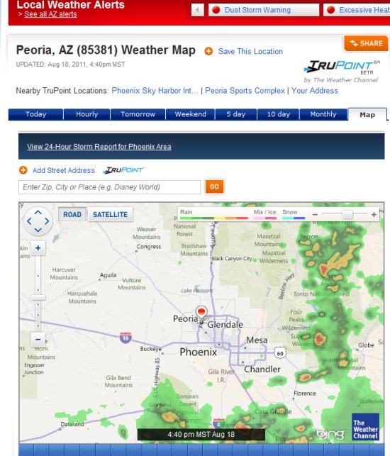
Aug 19, 2011 12:07 AM #448
Been watching the radar. So far it seems the storms are tracking eastward though
Aug 19, 2011 06:21 PM #449
Cool Alan.
The sky from Jared's hospital room
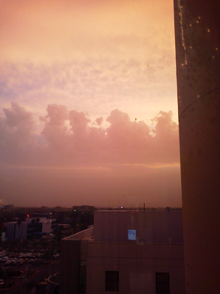
The sky from Jared's hospital room
Aug 26, 2011 07:23 PM #450
Really evacuating NYC? Wow. In Louisiana we got out the wake boards and tow straps
Sep 13, 2011 11:33 PM #451
If it makes it over South Mtn heat shield we should have some good storms shortly
http://www.wunderground.com/radar/radblast.asp?ID=IWA&lat=33.52722168&lon=-112.29499817&label=Glendale+Municipal%2C+AZ&type=N0R&zoommode=pan&map.x=400&map.y=240¢erx=541¢ery=246&prevzoom=zoom&num=10&delay=15&scale=0.433&showlabels=1&smooth=0&noclutter=0&showstorms=99&rainsnow=1&lightning=1
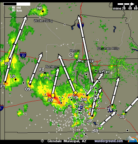
South Mtn webcam (if it works)

http://www.wunderground.com/radar/radblast.asp?ID=IWA&lat=33.52722168&lon=-112.29499817&label=Glendale+Municipal%2C+AZ&type=N0R&zoommode=pan&map.x=400&map.y=240¢erx=541¢ery=246&prevzoom=zoom&num=10&delay=15&scale=0.433&showlabels=1&smooth=0&noclutter=0&showstorms=99&rainsnow=1&lightning=1
South Mtn webcam (if it works)
Oct 26, 2011 10:16 PM #452
West side cell coming east down the 101
Oct 27, 2011 01:27 AM #453
east side was fantastic with all the rain...


Nov 07, 2011 06:54 PM #454
:)  :)
:)
http://www.forestlakesweather.com/live_camera.html
I swear I saw it dusting 4peaks yesterday too.
http://www.forestlakesweather.com/live_camera.html
I swear I saw it dusting 4peaks yesterday too.
Nov 07, 2011 08:22 PM #455
Planning on heading that direction in a couple weekends :)
Dec 02, 2011 05:05 AM #456
Payson Rim area
Rest of Tonight
Rain and snow. New snow accumulation 2 to 4 inches. Snow level 6000 feet. Lows 30 to 36. Light winds.
Friday
Colder. Snow and rain. Snow accumulation 2 to 4 inches. Storm total snow accumulation 4 to 8 inches. Snow level 5000 feet. Highs 37 to 45. Light winds becoming south around 15 mph in the late morning and afternoon.
Friday Night
Cloudy. Snow and rain showers in the evening...a chance of snow and rain showers after midnight. Snow accumulation 1 to 2 inches. Snow level 4500 feet. Lows 27 to 33. Light winds.
Saturday
Snow and rain showers likely. Light snow accumulations. Snow level 4000 feet. Highs 36 to 44. Light winds becoming southwest around 15 mph in the afternoon.
Saturday Night
Mostly cloudy. A chance of snow and rain showers in the evening...a chance of snow and rain showers after midnight. Snow level 4000 feet. Lows 21 to 27. Light winds becoming north around 15 mph after midnight. Chance of precipitation 40 percent.
Read more - http://w.po.st/share/entry/redir?publisherKey=underground&url=http%3A%2F%2Fwww.wunderground.com%2Fcgi-bin%2Ffindweather%2FhdfForecast%3Fquery%3Dpine%252C%2Baz&title=Weather%20Forecast%20-%20Pine%2C%20AZ%20-%20Local%20%26%20Long%20Range%20%7C%20Wunderground&sharer=copypaste
Dec 02, 2011 01:32 PM #457
Wanna go play in the snow...
Dec 03, 2011 02:54 AM #458
Been working in the snow for the last 2 days....
Mar 17, 2012 05:41 PM #459
...WINTER STORM WARNING NOW IN EFFECT FROM 10 PM THIS EVENING TO
8 PM MST SUNDAY FOR ELEVATIONS ABOVE 5000 FEET...
* TIMING...HEAVY SNOW WILL BEGIN ABOVE 6500 FEET OVER WESTERN
YAVAPAI COUNTY BY MID-EVENING...REACHING THE I-17 CORRIDOR
BEFORE MIDNIGHT TONIGHT...AND THE EASTERN MOGOLLON RIM SEVERAL
HOURS AFTER MIDNIGHT. THE HEAVIEST ACCUMULATIONS AND HIGHEST
SNOWFALL RATES WILL OCCUR ALONG A COLD FRONT...WHICH WILL CLEAR
THE AREA FROM WEST TO EAST BY LATER SUNDAY MORNING. SNOW LEVELS
WILL PLUMMET BEHIND THIS FRONT...WITH MODERATE TO HEAVY SNOW
SHOWERS RE-DEVELOPING BY SUNDAY AFTERNOON AND EVENING. MOST
PRECIPITATION WILL THEN BECOME MUCH MORE SCATTERED IN COVERAGE
AS WELL AS SHOWERY IN NATURE SUNDAY NIGHT AND MONDAY.
* SNOW ACCUMULATIONS...STORM ACCUMULATIONS BY SUNDAY EVENING WILL
RANGE FROM 15 TO 22 INCHES ABOVE 7000 FEET...10 TO 18 INCHES
FROM 6000 TO 7000 FEET...AND 4 TO 8 INCHES FROM 5000 TO 6000
FEET. AN INCH OR TWO IS POSSIBLE WITH ANY HEAVIER SHOWERS AS LOW
AS 4000 FEET...BUT THIS IS NOT EXPECTED TO BE WIDESPREAD.
SEVERAL MORE INCHES ARE POSSIBLE SUNDAY NIGHT THROUGH MONDAY
AFTERNOON...ALTHOUGH SNOWFALL RATES AND AMOUNTS ARE NOT
EXPECTED TO EXCEED ANY CRITICAL VALUES.
* SNOW LEVELS...AROUND 7000 FEET EARLY SATURDAY EVENING DROPPING
TO NEAR 4000 FEET BY SUNDAY AFTERNOON.
* OTHER IMPACTS...SOUTHWEST WINDS 20 TO 30 MPH WITH HIGHER GUSTS
ARE LIKELY THROUGH MUCH OF THIS STORM. THIS WILL CREATE AREAS OF
SIGNIFICANT BLOWING AND DRIFTING SNOW...AS WELL AS VERY LOW
VISIBILITIES.
PRECAUTIONARY/PREPAREDNESS ACTIONS...
A WINTER STORM WARNING MEANS SEVERE WINTER WEATHER CONDITIONS ARE
EXPECTED OR OCCURRING...DUE TO SIGNIFICANT AMOUNTS OF SNOW AND
STRONG WINDS PRODUCING LIMITED VISIBILITIES.
DRIVING WILL BE EXTREMELY DANGEROUS DURING THIS STORM. IF
POSSIBLE...POSTPONE TRAVELING IN THE WARNING AREA UNTIL THIS STORM
PASSES.
http://www.wrh.noaa.gov/fgz/
Mar 18, 2012 10:45 PM #460
Pulling into Payson


Still in Payson

This was at the lake right off Main Street in Payson.
 \
\
This was heading back towards Phoenix about 2 pm.. couldn't see a thing.

Sycamore area

Still in Payson
This was at the lake right off Main Street in Payson.
\This was heading back towards Phoenix about 2 pm.. couldn't see a thing.
Sycamore area