|
|
|
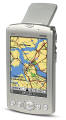
Specifications |
-
Powerful 200 MHz processor powering Palm OS
5.2.1 Garnet
-
Integrated Que technology, with Garmin GPS
and mapping software
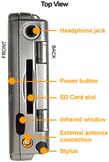
-
Flip-up integrated GPS patch antenna can be
positioned for optimal reception
-
Speaker for voice-guidance commands, MP3
player, and message playback
-
Voice recorder for making memos, quick notes,
and messages on the fly
-
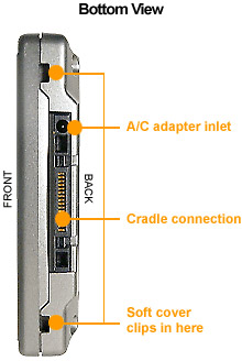
Rechargeable internal Lithium-ion battery
(charges in cradle or while connected to adapter)
-
Built-in 32 MB of memory for downloading map
data and other Palm OS-compatible software
-
ARM 9 processor enhances screen redraw,
graphics, and audio
-
SD expansion slot for flexible memory storage
and additional software
-
Unit size: 2.8"W x 5"H x .8"D (72 x 128 x
20.3 mm)
-
Display:
2.16" x 3.24" (54 x 81 mm), Backlit, 320 x 480-pixel, TFT
high-resolution, color with virtual Graffiti� area
|
|
Standard Applications |
-
Garmin� "Que" apps: MP3, GPS
Clock, Address Lookup, Electronic Mapping, Track log, Trip
Computer, Automatic Route Generation, and Turn-by-Turn Voice
Guidance
- Palm
OS 5 apps: Address Book, Calculator, Date Book, Memo
Pad, and To Do List
|
 |
Moving map
features |
-
Basemap: Built-in routable
basemap contains state and country boundaries, lakes,
rivers, streams, airports, cities, towns, coastlines, state
and interstate highways, local thoroughfares, and secondary
roads within metro areas
-
CD-ROM: Accepts downloadable map detail from Garmin
PC-based MapSource� City Select� CD-ROM which provides
street-level detail, addresses, listings of nearest
restaurants, hotels, ATMs, and more
|
|
Navigation
Features |
|
|
|
GPS performance |
|
Receiver: WAAS-enabled, 12
parallel channel GPS receiver continuously tracks and uses up
to 12 satellites to compute and update your position |
 |
Acquisition times:
- Warm: Approximately 15
seconds
- Cold: Approximately 45
seconds
- Autolocate�: Approximately 5
minutes
|
Update
rate: 1/second, continuous
-
Interfaces: USB, Infrared, RS232
-
Antenna: Flip-up, adjustable GPS antenna
|
|
GPS accuracy:
- Position: < 15 meters, 95%
typical**
- Velocity: 0.05 meter/sec
steady state
|
WAAS accuracy:
- Position: < 3 meters, 95%
typical**
- Velocity: 0.05 meter/sec
steady state
|
|
Power
|
|
Source:
Lithium-ion battery
Battery
Life: Approximately 2 weeks standby time or
approximately 10 days if used an average of 30 minutes per day
with backlight off. Battery life will vary depending upon
temperature and individual use patterns.
|
A
little info on the included mapping software:
Garmin
licensed the NAVTECH map data which is one of the most detailed and
updated map sources. The North America map bundle includes
street-level maps and hightway data of the US as well as selected
metro areas of Canada. The street-level maps and database from
NAVTECH include a large number of POIs (points of interest). They
not only get the most up-to-date material collected from all levels
of government, planning agencies, police and fire departments and
aerial photographs, but also they have a unique approach to
collecting hands-on data in real time. NAVTECH has over 100 field
offices staffed with over 400 analysts and engineers who drive
everyday to collect data and feed it daily to the live database.
NAVTECH uses up to 150 data attributes in each road segment that may
affect the way you get from one place to another. These road
attributes are characteristics of the roads and include Road Names,
Address Ranges, Turn-restrictions, One-way Info, Time of Day
Restrictions, Speed, and more. So the data you get from the NAVTECH
database is not only updated frequently but is the most complete in
terms of road and traffic conditions. If you wish to sample the map
data, you can use MapQuest.com since it also uses the map data
provided by NAVTECH.
 |
Be
sure to also check out the topographic map software for your
GPS at
Maptech.com. It works the same as other maps where
your coordinates are still displayed and tracking is real time
where the map moves with you and your position This is
the best software you can have with you hands down. |
|
Otter Box 3600 Specs |
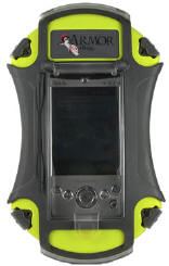 |
- Easily use PDA through recessed,
clear plastic screen
- Portals for printer, GPS, othe cable
connections
- Waterproof, dustproof, airtight, and
crushproof
- Secure stylus holder on outside of
3600
- Neoprene Velcro hand strap
- Unconditional lifetime guarantee
- ABS rubberized shell
 |
|