Read-Only Archive โ€” 68,067 posts ยท 4,889 threads ยท 2,978 members ยท preserved from 2006โ€“2015
Tonto Creek Wilderness 5-29-10
#1
Uncharted adventure with gains uncertain

This trip pros:
Promise of new found unspoiled territory
Wilderness solitude
Route finding
Teamwork

This trip cons:
Must drink enough water before the trail
Maps no matter how much you love them can lie
Route finding
Should have brought the radios

Trippees:
Dana (Yellowsub)
Jared (Spshl J)
Jonathan (Silversides)
Kira
Paul (Sc00by)
Me (Skatchins)

Day 1:

It had looked like Jonathan and I may be doing a duo trip into the wilderness for Memorial Day Weekend, it soon developed into a six person trip instead.
Our general trip requirements were a lack of people, but on the water camping. Those two don’t usually go hand in hand so we began researching options. After consulting topo maps, older and newer and aerial photography, we set our sights on Tonto Creek between the popular Hellsgate Trail east of Payson and the town of Gisela.
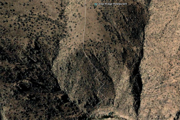
According to the newer maps a pack trail did in fact drop us into the creek’s Wilderness Area with a series of switchbacks after a lengthy 4wd trail up into the hills. Instead of seeing how much pavement we could cover into Young before hitting dirt, we decided to hit it at Jake’s Corner and stay off road the rest of the way. Definitely a 4wd trail, clearance and some looser hill climbs came into play. Paul’s lockers really helped on the ups but we both kept on keeping on until we were topside in the Sierra Anchas. I did suffer a punctured tire from a rock, but with some quick moves, we got the compressor on it and got it plugged up before it got too low.
Topo maps offer all kinds of goodies that usually become forgotten, such as old cabins, ruins, etc. Our map quad included both so we took a route that would put us closer to them. Fred Pranty’s cabin was our first goal. A homestead built for gold mining near Gun Creek, it still stands since the early 1900’s. (Legend of Fred Pranty’s bones- http://www.paysonroundup.com/news/2002/oct/21/the_legend_of/?print)

It did take more work than originally thought to reach the cabin, but it was still miraculously intact after all this time. We explored around, admiring the craftsmanship and the use of local lumber paired with old wooden crates for the outer walls. Even most of the window glass was still unscathed. We ate an early lunch, shared with a new rat friend, and began driving out. There only two parts I was worried about getting back up. The first lent no problem and with some good spotting, we got the other without too much trouble. After the section I needed low range for, we found that she wouldn’t shift back out. Banging didn’t work, but praying did later on down the road as we continued on anyway.

The forest road that would take us the rest of the way wasn’t great all the way but it was so much better then the rest of the day’s offerings. We made it to Soldier camp but then realized we had missed our turn a mile back on the switchbacks. The road up top was almost long forgotten. Barely traveled, it was almost losable as it led us through meadow- like areas with long views below. Not long after we arrived at the wilderness boundary and our bailout point for what we thought would be the rest of the weekend.

According to the newer topographic map, we had about a 2mi hike ahead of us with about a 700ft drop in done with handy switchbacks. I believe I was quoted as saying “this won’t be as tough as the WCC Manmping trip drop in.” That would have been true if the switchbacks existed. A couple of the guys went down in search of trail remnants. Being the trip leader, I got tunnel vision and got set on reaching the bottom. As I got closer I began to realize I was out of water, but I continued on with the belief I could refill in just a few minutes at the bottom. Unfortunately the heat of the day, my lack of drinking on the drive in, and the 100ft cliff in front of me cancelled those plans. I panicked knowing I could probably/maybe safe-ishly finish my descent without my pack but also knowing the rest of the group was closing in on my position and some would probably not be able to. My legs began cramping as I weighed the options and I realized I was getting too close to not being able to make it back up on my own. I became worried about getting past the point of helping hydration wise and still worried the rest of the group would end up in the same boat as I was, facing a hike back up the 1000ft loose severe slant. The canyon walls with all of its echoes still offered no contact with the group above and the water just below taunted me with its rushing power. I dropped everything replaceable with the knowledge it may remain there and tried hiking back up. I had to stop way too often and there was no shade. About a third of the way up I fired off the gun hoping it would stop all of the group except the strongest, one that could offer me some assistance. It of course scared them to hear but my panic on the two things at the center of my brain felt it justified. I kept climbing until I could finally hear someone call back. Jonathan met me down where I had reached, and offered to retrieve my pack as I drank (I’m sure he had no idea of the progress I had made up the rock slides, lol). Alleviating the rest of the group’s fears that I was not completely bloodied over, I informed that we needed to head back, the route just wasn’t safe for us all. Of course I hadn’t been the only one getting short on water paired with the hike and the drive, everyone was low. Jared in his creek bottom search had found a water pool that he believed he and another could reach, fill up everyone’s rervoirs and make it back in about 45min. We agreed with the knowledge the hike back to the vehicles may be in the dark with our lights.

Eventually Jonathan returned with my belongings (thank you so much) and Jared and Paul returned with plenty of water for our trek back (thank you so much). We let them rest but probably not for long enough and hiked back. The GPS trackback helped us a couple of times stay true.

Finally back at the vehicles just as the last of the daylight faded, we unshouldered our packs and stripped down to skivvies and got into one of the larger creek pools nearby for some rejuve. Jared and Paul decided to head back before camp but the rest of us stayed to see the brilliant stars on the wilderness boundary. We campfired it up and then after eating and drinking as much as we could, we crashed out to the sound of Jonathan’s digital goats.

---------------------------------------------------------------------------------------------------------------

I know now that those short little lines are just dead cows that fell off the edge
attachment

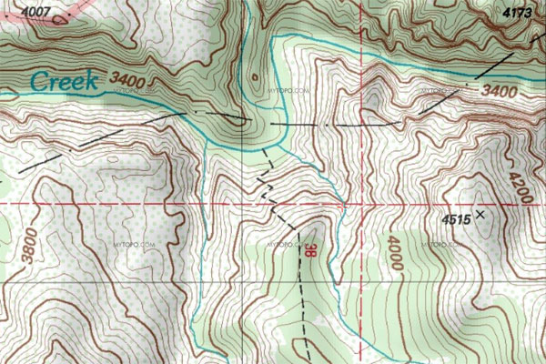
If you need further proof that maps sometimes just F with you
attachment
Horrible service by the way
#2
Day 2

Cliff's Fences

Trippees:
Dana (Yellowsub)
Jonathan (Silversides)
Kira
Me (Skatchins)

So you find yourself out in the wilderness, exhausted from the previous day’s “activities” and you think what now? The requirements are still the same (lack of people but abundant water) and you still have a pack full of supplies and plenty of time to kill. After Tonto Creek gave us the finger and us in unison back on the first attempt, what better way to get regain balance than to try another way in?

The tiny town of Gisela is the gateway to one of the best sections of Tonto Creek. Just at the end of the road lies the beginning of The Narrows. Like WCC’s Narrows, the creek walls creep in and the water depth drops. Unfortunately, because of the relatively easy access, the private lands and ranches in the area had become trashed from party-goer use. As a result Gisela has become a “town of fences,” with private property signs at every turn. Parking along the road is not an option either as the area is highly monitored by locals.

The simple hike in has just recently become a modified off trail hike (not to be confused with freehiking)on HikeArizona.com with the suggested route using ridgewalking until reaching a Tonto Creek tributary. Since we hadn’t planned on this venture, I did not have the route saved though I had studied it a time or two before.

We decided to give it a shot anyway since it was only about 8mi down the pavement where we would come out after tracing our steps back from Saturday. We drove to Gisela and then took a wash trail around the town to a hill top that lined up with the drop in. No matter what, the trail had to be easier with a 10lb pack compared to a 60lb one. With the GPS fired up, we followed the cow trails again along the ridges taking the few ups and downs for about 2 miles until we were faced again with a drop in. Unsure of the spot where the previous hikers had traveled down, we looked until following the slope down towards the road became the best option. I’ll go ahead and blackout the next part to protect the innocent followers, but lets just put it out there that we obviously tried our darndest to abide by the property lines as seen by our GPS route through the rough terrain over and above the town. There may have been a few steps out of place but we tried.

Anyway back to sticking it to Tonto Creek, perseverance, etc, etc... We got there with no shots fired this time, blew up the tubes and headed upstream to where the waterfalls could be heard rushing. The big pool at the start was footballfield long and at least 40ft deep. Large 1.5-2’ carp and trout could be seen swimming by. We paddled through the narrow section and came out at the first falls. We all did the first section a few times but Jonathan and I did the higher start version that almost promised a bloody head to match our cat-clawed legs. I made it through three times unscathed but after Jonathan’s rapid-shoot, he realized his ring finger had gone naked. There was no hope in finding it in the waters no matter how clear they were. He did give it a few tries and he was at least, visibly outside, a good sport about it.
We tubed up a little bit but didn’t explore too far this trip for fear of being short on daylight on the way out.

We got back to our creek start and discussed our options. The girls, we all decided, were not wanting the hike up the loose hill topside, so we did what any horror movie would dictate and split up in a small township of overly private people that hates outsiders other than sprinkled in their meals: We sent the girls down the two miles of flat road as Jonathan and I braved snipers going back the way we came. We actually made great time after being rejuvenated in the creek and it only took us an hour and a half to reach the vehicle. We loaded up and met the girls at the waypoint we had directed them to near the wash exit. They were unscathed and we regrouped for our next plans. While we all had a desire to camp again, no group member knew another spot close worth the drive at dusk, so we went to the only other watering hole we knew to complete the trip: Dana and Jonathan’s hot tub. Miraculously there were no people there either- But there was ice cream.
#3
Glad you are ok. Extra glad I didn't go. I would have had to kill you...;)
#4
Glad to see everyone made it back safely.
#5
fatbob309 wrote:Extra glad I didn't go.


I made it a hard trip just so you would be able to say that
#6
I'm out of breath and looking for a Dairy Queen just reading this, you know.

I too am really glad you are OK, brother. I confess, I didn't pray for everyone's safety like I typically do when I know everyone is headed out. I'm truly grateful He was protecting and watching out for each of you. (I'm also glad you got to shoot your gun. That's always good, no matter what the circumstances. 8) )
#7
During our time of not "knowing" Mikes condition Dana had asked us to pray,
I did & there was other prayers going out too along our hike out too.
God does work in strange ways... Had Jared not went looking for another trail he wouldn't of found that water hole that eventualy helped us!
In all I'm thankful we all made it out safe and am thankful for the experience, its a reminder that were not always as prepared as we think & no matter what bring more water than you'll think you'll need!

And I'm sorry for leaving that evening, but I was done... My feet were trashed & over all I was so exhausted & thirsty, the drive back to asphalt seemed to take forever but we were able to make it out.
Sorry again for bailing out like I did :(
#8
Added day 2
There were 4 cameras out there so some pics should follow soon.
#9
Despite so many changes to our original plans, we all still had a great time. We were all so relieved when we finally reached the water!! Thanks for planning this Michael!


#10


#11
And now it's time for the videos of the waterfall

Michael


Jonathan


Me


Jonathan again
#12
Sweetness. Call me crazy but after seeing those I want to go back already :))
That skinny dude's got some faces on him!
#13


The crates used for the cabin walls
.

The trail's start at the wilderness boundary


The view from the top before the attemped descent


Hiking back as the shadows came


#14
Good pics... I'm proud of you gettin' some people shots! :)) The cabin pics turned out nicely. How'd your chippin window pane paint pic come out? (Say that 3 times fast:p)
#15
Cool stuff! Glad you guys make it out ok.
#16
Ok my turn...
Mike's creek crossing


Cabin


On our way out


The hike in


#17
Amazing pictures guys, sorry I missed it.
#18
howd all those people get in your pics. You shoulda waited for them to move ;)